Framework Vision Plan for Dog's Head
Download PDF
1 / 1
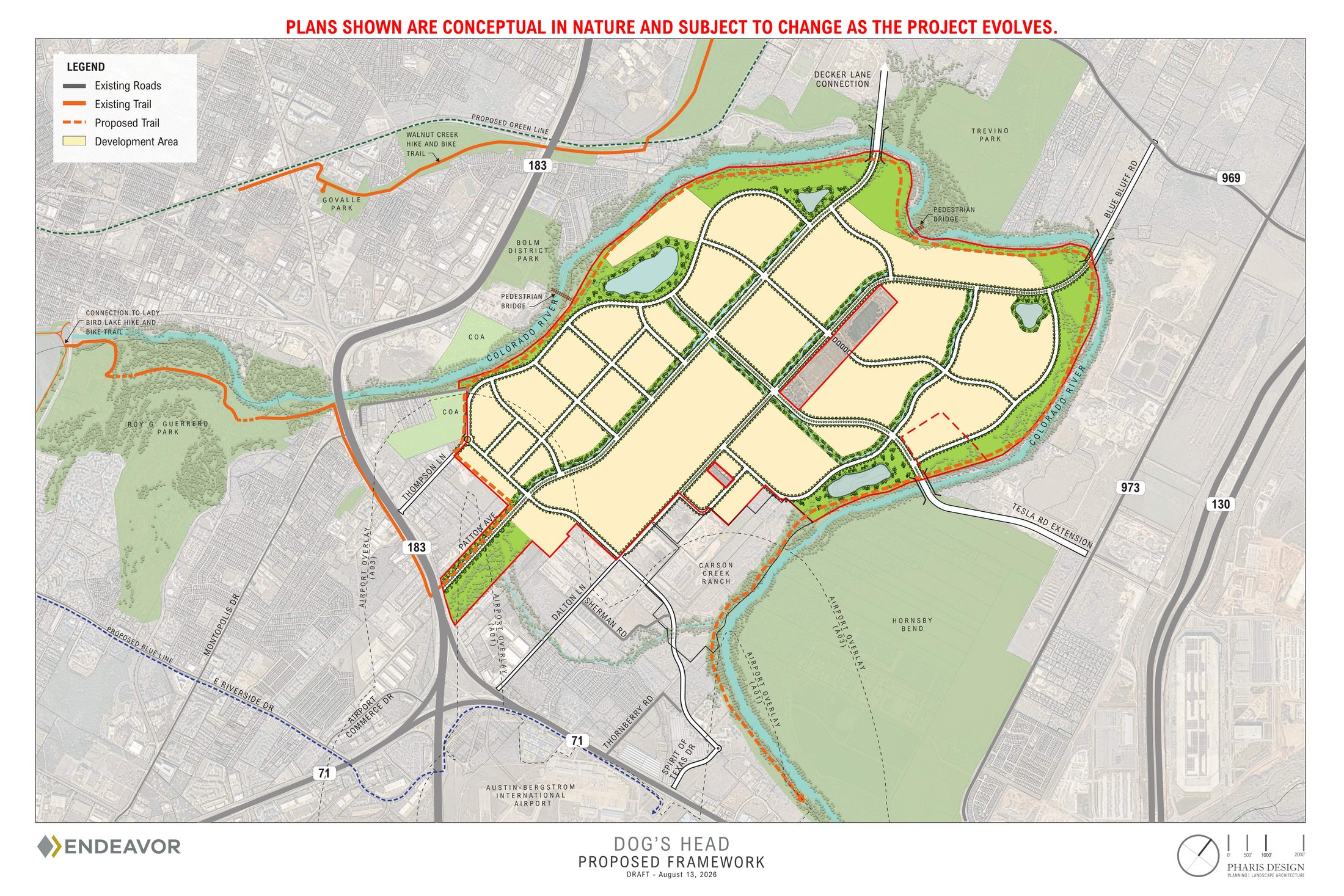
Plans shown are conceptual in nature and subject to change as the project evolves.
A guide to what's being proposed for over 2,600 acres on the Colorado River: the history, the numbers, how the financing actually works, and clear answers to the questions the community has raised.
"Dog's Head" is the name for a group of tracts that wrap around a bend in the Colorado River, east of downtown Austin and north of the airport. The land was recently annexed into the City of Austin under a long-term development agreement.
In the coming decades, the Dog's Head project will responsibly transform a former sand and gravel mining site into a place where Austinites will one day walk, bike, and enjoy more than six miles of trails along the Colorado River.
Dog's Head brings jobs, housing, public infrastructure, and lasting community benefits that strengthen Austin for generations.
This is a 45-year framework for building out an entire mixed-use area in phases (housing, employment, retail, and open space/trails), rather than one project with a single ribbon-cutting date.
3.5 miles from downtown Austin, the tract loops around a meander of the Colorado River between US-183 and SH-130, north of the airport. The shape of that bend is where the "Dog's Head" name comes from.
The scale of this project is unusual. It represents one of the largest annexations Austin has seen in decades and is a chance to restore previously mined land, expand public access to the Colorado River and create jobs, housing and public infrastructure. Projects of this scale naturally generate questions, and we've addressed many of the most common ones below:
Acreage compared to two developments Austinites know well.
Dog's Head is about 9× the size of the Domain and nearly 4× the size of Mueller.
As another scale reference, City officials have described Dog's Head as roughly the size of Downtown Austin and the UT campus combined, stretching all the way from Mopac to I-35 (east to west) and from Lady Bird Lake to north of UT Campus (north to south).
Since the 1950's, Dog's Head operated as a local quarry, supplying sand, gravel, and sandy loam to the entire region.
Much of the land interior to Dog's Head today consists of open pits and earthen scars from the mining activity, undeveloped and inaccessible to the public. At the same time, the river's edges, which will be protected, remain natural and beautiful.
Both of those things are true, and both matter for what happens next.
Over 80% of the site was mined for aggregate over many decades.
The site is under active reclamation as it transitions away from mining.
An opportunity for Austin to grow sustainably, protecting the environment while creating an economic engine that benefits East Austinites.
One of the most common questions we've heard is what the project will ultimately look like. That's a fair question. Large-scale projects like Dog's Head are planned and built over decades, not all at once. The long-term vision and public commitments are established today, while specific buildings, tenants and uses will be shaped over the coming decades.
Here's what's already committed, and what will continue to evolve through future planning.
As additional details are finalized through future planning and public review, we'll continue updating this page with the latest information.
Understanding how growth is financed in Texas helps explain why this project is structured the way it is. Here's a straightforward overview of how it works.
Ultimately, the public does. Streets, water/sewer lines, and drainage systems are typically dedicated to the City once they're built and inspected. The City then owns and maintains them as part of the public system, the same as anywhere else in Austin.
For a district this size, it's a mix (and this is where the honest nuance matters). In smaller "infill" projects, a developer builds the internal infrastructure and hands it over. For something the scale of a new district, the roads, bridges, water lines, and drainage needed are far larger than one project can carry alone, which is why public financing tools exist.
Here, the plan is for the developer to front all infrastructure costs, with a TIRZ reimbursing a portion of the anticipated infrastructure over time, and only from new tax revenue that the development itself generates. More on how that works in the next section (TIRZ).
Cities generally don't have hundreds of millions of dollars (let alone billions) sitting idle to extend roads, bridges, and utilities into a raw site on the chance that development follows. Tools like a TIRZ are designed so that the private developer takes that up-front risk and gets paid back only if the new value (and the new taxes) actually materialize. If it doesn't pan out, the developer, not the taxpayer, absorbs the loss.
The TIRZ is one of the most important parts of the project, yet is one of the least familiar. Here's a straightforward explanation of how it works and the questions we've heard most often.
Learn more about Tax Increment Reinvestment Zones on the City of Austin's website →
A Tax Increment Reinvestment Zone (TIRZ) is a financing tool used to fund public improvements. It doesn't create any new taxes. Instead, it reinvests a portion of the future property tax revenue generated within the zone to pay for public improvements inside that same zone.
For Dog's Head, the City (and, if approved, the County) will use the newly formed TIRZ to reimburse the developer for building public infrastructure that becomes City-owned. The developer can only be reimbursed if the property and sales tax generated within the TIRZ is enough to cover those costs.
Your tax rate and your tax bill are not changed by the TIRZ. A TIRZ doesn't raise anyone's taxes, and it doesn't touch the taxes already being collected today. The existing "base" value keeps flowing to the City's general fund exactly as before.
What the TIRZ captures is purely the increment, which is the new tax revenue from new value that exists because the development happened. A portion is set aside inside the zone to pay for the roads, drainage, and utilities the district needs.
No school districts have been asked to participate in the Dog's Head TIRZ. Del Valle ISD will receive 100% of all incremental value generated by the TIRZ.
The Dog's Head development provides a growing tax base that will help fund parks, infrastructure and other essential City services outside of Dog's Head boundaries like public safety, water, health and human services.
It's not a check written to a developer. A TIRZ is pay-as-you-go reimbursement: the developer spends its own money to build public infrastructure first, and is only reimbursed later, and only from the new tax revenue that the completed development actually generates.
If the value never materializes, there's nothing to reimburse. The developer absorbs that risk, not taxpayers. That risk-shifting is the core reason the tool exists.
It shifts both the cost and the risk off the City's books. If the City built this infrastructure directly, it would have to borrow against general revenue and compete with other citywide priorities, with existing taxpayers carrying the cost.
Instead, the developer pays the upfront construction cost and is repaid only from the new tax revenue the redevelopment produces above today's base. If the project underperforms and that revenue doesn't materialize, the City has paid nothing and existing taxpayers aren't on the hook.
Austin's future depends on attracting investment that creates jobs and grows the tax base.
This is central to the whole decision. Without the TIRZ, Dog's Head has the option to reverse City annexation and develop the property under Travis County rules instead (outside of Austin's ETJ).
County regulations carry no land use or zoning restrictions, minimal public-benefit requirements, and zero city oversight or involvement. The commitments negotiated into the city agreement (20% affordable housing, 266+ acres of designated open space, the public river trail, and the City's specific environmental regulations) are not things that would be required in the County. And the City would capture none of the new tax value.
So the honest choice here isn't the agreement versus a blank slate. It's the agreement (which has been significantly strengthened since its initial approval in May) versus development the City would have far less ability to shape. We think both the benefits and the criticisms raised are best weighed against that real alternative, rather than against an outcome that isn't actually available.
Yes. The property suffers from inadequate infrastructure (streets and public utilities) and, given its size, location, and physical characteristics, won't develop effectively through private investment alone in the foreseeable future.
State law allows a TIRZ where an area is predominantly unproductive or underdeveloped (for example, because of missing or aging public infrastructure and the need for economic incentive to attract development). Financing the public improvements as contemplated in the Preliminary Plan is expected to bring quality development and a stronger real-property tax base for all taxing units in the zone.
The current net Travis County Appraisal District (TCAD) value across the 2,614 acres annexed in June 2026 is approximately $17 million (the "base value" the TIRZ starts from).
The Preliminary Project and Financing Plan estimates total infrastructure costs over the 35-year term at over $5 billion, including roads, utilities, bridges, and other public infrastructure.
Projected reimbursement from the City and County TIRZ is about $1.5 to $1.6 billion, net of bond interest and issuance costs. The remaining $3.4 to $3.5 billion is at the developer's risk, since reimbursement only happens if the tax revenue supports the bonds.
TIRZ revenues can only reimburse costs related to designing and constructing public infrastructure (like roads, drainage, utilities, and water-quality controls). These costs are itemized in the Project & Financing Plan for the TIRZ.
Yes. The City's full tax rate, including the ATP (Project Connect) sub-rate, is being captured inside the TIRZ boundaries.
Participating in the TIRZ would let Travis County reinvest in infrastructure and public improvements that directly benefit the area, including drainage and floodplain improvements for nearby Carson Creek and regional transportation connections that wouldn't be possible without the TIRZ. The increased property taxes generated by a large-scale mixed use development can also provide fiscal benefits that serve all Travis County residents.
The term of the TIRZ is 35 years. Note: The development agreement itself runs longer (45 years) but the two terms are separate.
The TIRZ is created and administered by the City of Austin, with Travis County's potential participation contemplated as well. Alongside the TIRZ, all development on the site remains subject to City review, including a dedicated Dog's Head permit review team.
The City will oversee the Dog's Head TIRZ in a similar manner to its management of other current & former City TIRZ projects, like Mueller, Colony Park, Waller Creek, and Seaholm.
Community engagement has helped identify the topics people care about most. Below are answers to many of the questions we've heard in recent months.
Impervious cover is the share of a site covered by hard surfaces (buildings, roads, and parking). On July 23, 2026, City Council adopted an amendment capping impervious cover at 79% across Dog's Head mixed use development areas.
This is a negotiated figure, lower than the typical 80% impervious cover for commercial property in an urban watershed.
Note: The open space areas will remain largely pervious, with a lower 20% impervious cover cap.
No. The banks of the Colorado River are part of the Critical Water Quality Zone (CWQZ), where development is tightly limited. For Dog's Head, the CWQZ is a buffer that begins at the river's Ordinary High Water Mark and ranges from a minimum of 200 feet up to 400 feet wide, following the 100-year FEMA floodplain, and the CWQZ is extended further wherever that floodplain is wider than 400 feet.
Together, that protected area is equivalent to roughly a 300-foot average setback from the river (about 236 acres). Within it, only limited uses are allowed, such as nature trails, public access points to the river, regional stormwater outfalls, and clearing of invasive species, under the conditions set in Section 5.08 of the Development Agreement.
The Development Agreement establishes the Critical Water Quality Zone (CWQZ) along the river, where development is extremely limited. Where the bank is actively eroding, the Agreement authorizes slope stabilization with required protective works. And by concentrating most of the site's stormwater into a regional system with a limited number of controlled outfalls, the plan is designed to reduce erosion risk along the shoreline.
All development within Dog's Head must meet the City of Austin's water-quality treatment requirements in effect as of May 21, 2026. Stormwater quality is managed through control facilities that must demonstrate compliance with the City's Environmental Criteria Manual (ECM). The agreement also allows for the on-site former mining ponds to be used as water quality ponds, provided they meet those same ECM standards.
Any runoff from the development will be treated to remove pollutants, in accordance with the City of Austin's applicable water-quality standards.
No. There are no federal wetlands on the property, based on a jurisdictional determination approved by the U.S. Army Corps of Engineers.
FEMA's Flood Insurance Rate Maps (and various online map viewers) currently show approximately 752 acres of floodplain across the 2,614-acre Dog's Head property.
Yes. All of Dog's Head's internal drainage systems will be subject to Atlas 14, which is the updated rainfall data Austin uses for floodplain and drainage design.
A small portion of Dog's Head is within the Carson Creek watershed. If additional land is later added to the property, the Critical Water Quality Zones for Carson Creek would apply.
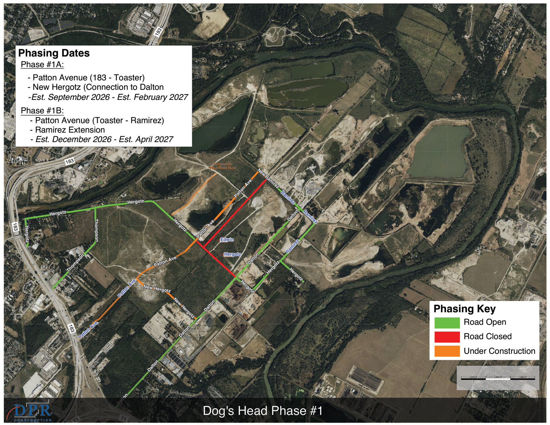
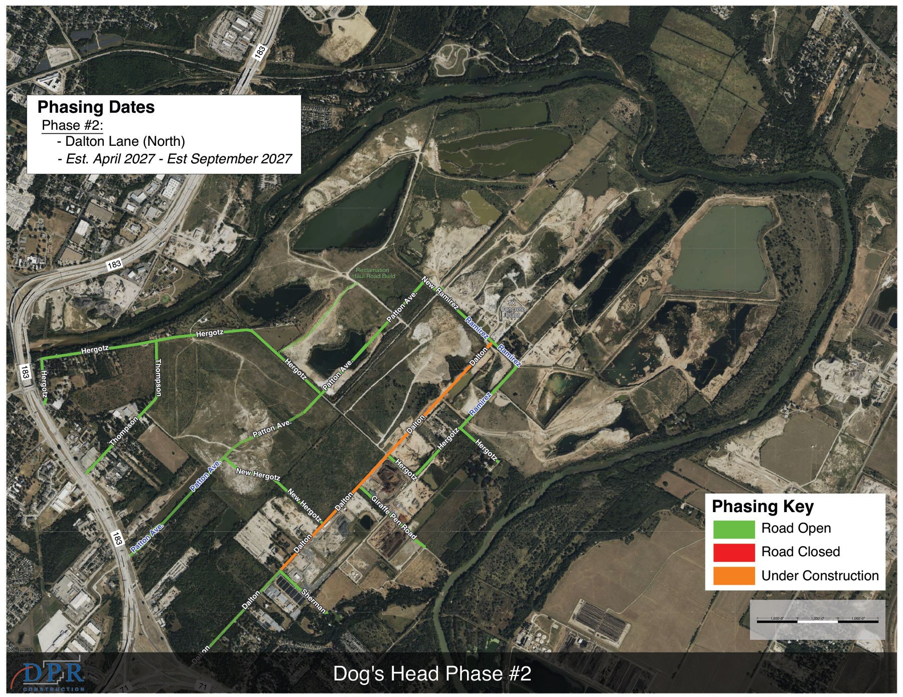
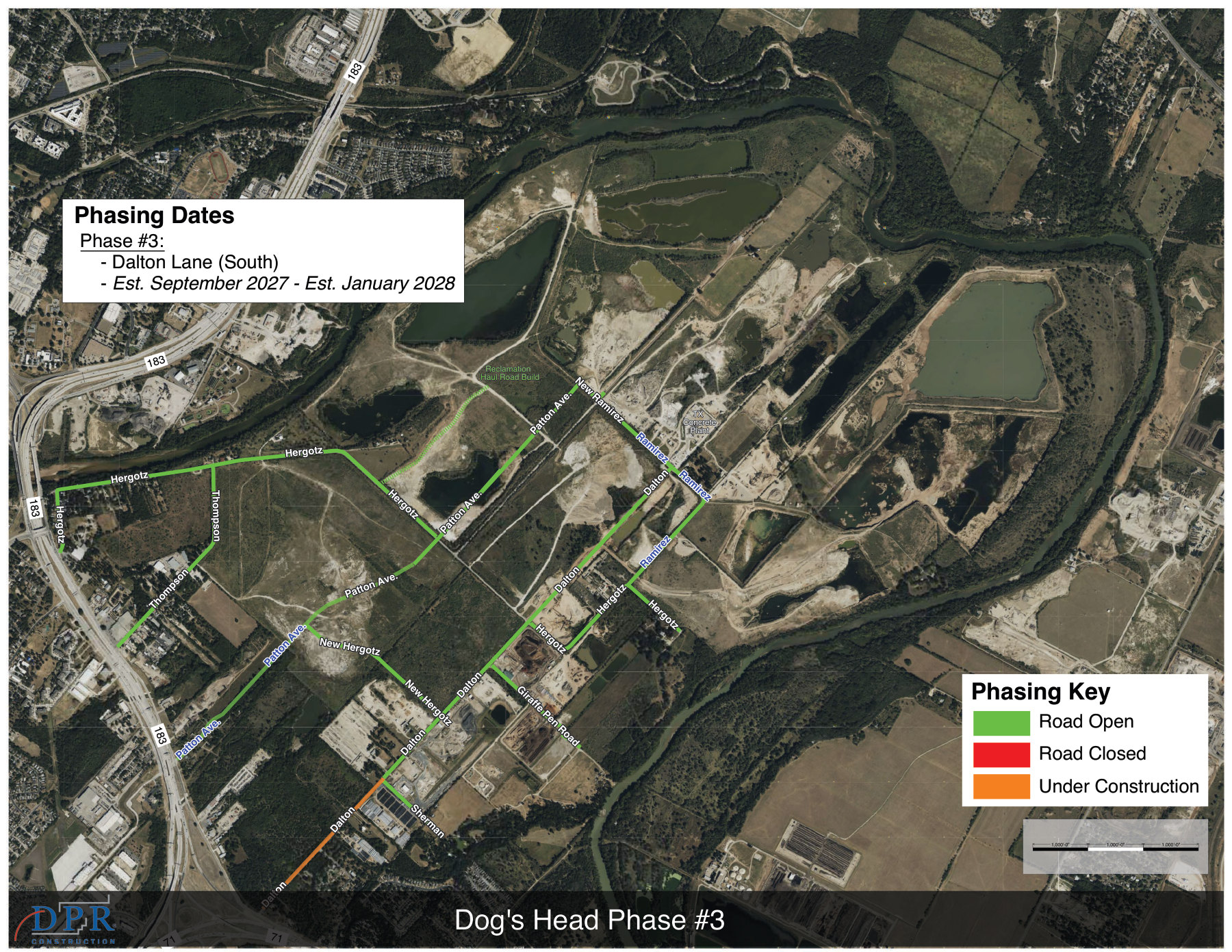
The development also triggers upgrades to existing portions of Patton Avenue and Dalton Lane, including new stormwater infrastructure and floodplain modifications that may remove parts of those roadways from the 100-year floodplain. Any proposed road upgrades will improve them without creating an adverse impact to the Carson Creek floodplain and may even improve the Carson Creek floodplain.
Yes, there are existing trees, primarily within the Critical Water Quality Zone along the Colorado River. A tree survey is required in the Critical Water Quality Zone.
Yes. Trees and other landscape improvements will be planted within individual development sites and throughout the project.
Establishing the regional stormwater system will also include native seeding and planting.
The Colorado River Corridor Plan (created jointly back in 2012 by Travis County, the City of Austin, and the Lower Colorado River Authority) aims to guide orderly growth in the corridor while preserving its environmental, recreational, and cultural resources: floodplain and natural-area preservation, parks and greenways, biodiversity protection, and long-term reclamation of former mining sites.
Dog's Head is a former sand-and-gravel mine now under reclamation, and the Development Agreement is designed to directly advance the objectives of the Colorado River Corridor Plan written almost 15 years ago. At full build-out, Dog's Head is expected to provide a publicly accessible Colorado River trail, a minimum of 266 acres of permanent publicly accessible open space, a protected buffer/greenway along the river, and a regional stormwater system that allows for natural-state restoration of the major drainage channels.
Yes. Dog's Head is an active reclamation site, meaning it is being reclaimed and repaired from its prior condition as a mining and quarry site.
Sand, gravel, and sandy loam soil have been mined on the site for many decades.
Reclamation is done through a combination of bringing in fill (dirt, sand, gravel, crushed rock, and the like) and regrading the existing site.
Ongoing reclamation activities will not have an adverse impact on the Colorado River floodplain or on other property owners.
Cut-and-fill limits never applied to the decades of mining on this site, which created slopes and excavations exceeding 30 feet. Cut and fill beyond four feet is necessary to reclaim the site from that prior mining activity and enable development to occur.
Under the Development Agreement, standard cut-and-fill restrictions don't apply except in limited circumstances within the Critical Water Quality Zone.
All development on the property is subject to City review (including environmental review and inspections) and must comply with the City's existing environmental regulations except where the Development Agreement specifically modifies them. The City has established a dedicated Dog's Head permit-review team and a long-range planning team for the entire site. The Texas Commission on Environmental Quality has jurisdictional authority over mining activities.
No. The Texas Fatmucket has not been documented within this stretch of the Colorado River in recent decades.
The migratory bird community is an important priority to protect and thoughtfully consider. The Dog's Head team is discussing options to protect birding habitat with appropriate experts.
Short, factual answers to the questions we've heard most. If your question isn't here, ask us directly below.
The property is not a PUD. A Regulating Plan will be created that is consistent with the terms of the Development Agreement and State law.
The decision to bring Dog's Head into the City was an annexation negotiation, not a zoning case.
It's a phased, 45-year project rather than a single building or phase. The Austin City Council approved the TIRZ in July 2026, and early phases will begin as the former mining land is reclaimed. The first ~2 mile section of the public trail is targeted within 18 months of TIRZ adoption, with the broader district taking shape over the decades that follow.
Use the Get Involved section just below to submit a question or sign up for project updates. If something on this page is unclear or you think it's wrong, we want to hear it.
Development on the property must comply with the City's Land Development Code as it existed on May 21, 2026, except as modified by the Development Agreement.
Mixed use, residential, retail, office, industrial, and civic uses are allowed. A full list of allowed uses is included in Exhibit B of the Development Agreement.
Except for certain types of uses, the Development Agreement does not limit where uses can be developed. Spacing requirements are set out in Section 3.14.
Section 3.07 and Exhibit C of the Development Agreement establish these standards.
Under a scenario that leans more toward commercial uses, the project could result in as many as 5,000+ residential units and 17+ million square feet of commercial space (retail, office, industrial, hotel).
Under a scenario that leans more toward residential uses, it could result in as many as 12,000+ residential units and 8+ million square feet of commercial space.
Affordable and attainable housing for Austinites is a priority. The 20% affordable housing component is a requirement of the current City of Austin TIRZ policy.
Under the Development Agreement, a total of 20% of the residential units will be income-restricted for 40 years. Of those units, the developer will provide 10% of the units as income-restricted, and the remaining 10% will be provided through public-private partnerships, grants, or other methods with the City.
Dog's Head is not pursuing large-scale data centers as prospective users. These facilities require a significant amount of power, typically 75 or more megawatts, and trigger an evaluation by ERCOT. Prohibiting all data centers would also rule out the smaller-scale, less intense data centers that already operate throughout the City, which are part of many ordinary office, industrial, and commercial activities.
The Development Agreement establishes the applicable land development regulations for the property. A regulating plan is essentially a mini Land Development Code for a specific area of the City, and in this case the regulating plan allows for consistency with the Development Agreement.
As the property transitions from a former mining site, a temporary hunting agreement will remain in place within a defined 400-acre area that is still undergoing heavy reclamation of open pits. The hunting agreement applies only to the long-time partners who have owned portions of the property for more than 100 years and their authorized guests. As soon as the future Colorado River trail reaches that area, all hunting will permanently end and no firearm activity will be permitted.
Parkland dedication is not required (and cannot be required) unless a developer constructs a residential or hotel/motel use. State law limits how much a city can require for parkland dedication to 10% of the gross site area.
Under the Development Agreement, Dog's Head is establishing a publicly accessible Colorado River Trail and a minimum of 266 acres of publicly accessible open space.
The Austin Strategic Mobility Plan (ASMP) is the City's long-range transportation plan that guides how it manages growth and improves mobility.
An amendment to the ASMP will evaluate the area's future transportation needs, so that planned roadways and regional mobility improvements can be coordinated as the community grows. The goal is a multimodal network that supports future growth while improving connectivity for residents, businesses, and the surrounding area. Mass transit will be an important aspect of the project.
The City and Dog's Head needed to efficiently decide whether to move forward on annexation, so the initial steps of this project in mid-2026 moved quickly.
We want to give the community ample opportunity to understand the project details, ask questions, and engage with us as Dog's Head begins to develop.